


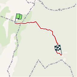
Col de la Gd Vache - Chalet de la Charmette (Allé simple)

crocau
User

Length
3.2 km

Max alt
1719 m

Uphill gradient
28 m
Km-Effort
4.9 km

Min alt
1292 m

Downhill gradient
418 m
Boucle
No
Creation date :
2019-08-04 09:08:51.493
Updated on :
2019-08-04 09:10:36.267
48m
Difficulty : Easy
30m
Difficulty : Easy

FREE GPS app for hiking
 SityTrail
IGN / Geographical institutes
SityTrail Plus
The world is yours!
About
Trail Walking of 3.2 km to be discovered at Auvergne-Rhône-Alpes, Isère, La Sure en Chartreuse. This trail is proposed by crocau.
Description
Départ: Col de la grand Vache
Retour vers le Chalet de la Charmette
Positioning
Country:
France
Region :
Auvergne-Rhône-Alpes
Department/Province :
Isère
Municipality :
La Sure en Chartreuse
Location:
Saint-Julien-de-Raz
Start:(Dec)
Start:(UTM)
712509 ; 5023988 (31T) N.
Comments